European Atlantic Geodiversity Conservation Charter
This Charter is published in 2020 by the Atlantic Geoparks Project co-funded by the Interreg Atlantic Area Programme through the European Regional Development Fund.
Foreword
[in preparation]
Introduction
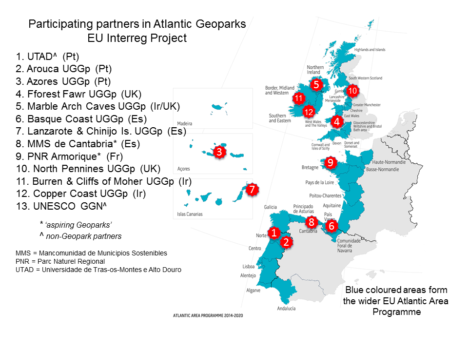
The EU ‘Atlantic Area’* extends down Europe’s western seaboard from Shetland to Andalucia, thereby including northern and western Scotland, the whole of the island of Ireland, all of Wales, northwest and southwest England along with western regions of France, northern and western regions of Spain and all of Portugal. The area also includes the Atlantic archipelagos of Madeira, Azores and the Canary Islands. Numerous existing Geoparks and a handful of aspiring Geoparks are to be found within this area of which eight existing ones and two aspiring ones (as of 2020) came together between 2016 and 2020 through the Atlantic Geoparks Project funded by the EU Interreg programme.
*all further references in this document to the ‘Atlantic Area’ refer to the area as defined for EU Interreg purposes
The Importance and Value of the Geodiversity of the Atlantic Geoparks
The astonishingly varied landscapes of Europe’s Atlantic fringe are the product of an immensely long geological history involving a wide range of earth processes, many of which continue to shape these areas to the present day. These developments have been supplemented by the increasing influence of one species, Homo sapiens to the extent that it is proposed that the modern epoch be re-named the Anthropocene; humans are arguably now the dominant force re-shaping the planet.
From the 3000 million year old Archaean gneisses of northwest Scotland (central to the character of the North West Highlands Geopark) to the lavas of Tiagua in the Lanzarote and Chinijo Islands Geopark which were erupted as recently as 1824, the rocks of this extensive region offer a window into the planet’s past.
The island Geoparks within the Atlantic Ocean chart the opening of this ocean over the last 200 million years. Other Geoparks notably those in Britain and Ireland record the closure of Iapetus, an ocean which predates the Atlantic, and the mountain-building associated with that extended continental collision. Later mountain-building episodes attended the closure of both the Rheic and Tethys oceans, processes recorded in the geology of several Geoparks.
[Geodiversity] is the variety of rocks, landforms, sediments, soils and the natural processes which form and alter them.
[Geoheritage] is those elements of our geodiversity that have significant intrinsic, cultural, aesthetic, scientific or educational value.
Geoparks collaborating in the Atlantic Geoparks Project:
- Arouca
- Azores
- Basque Coast
- Burren & Cliffs of Moher
- Copper Coast
- Fforest Fawr
- Lanzarote & Chinijo Islands
- Marble Arch Caves
- North Pennines
Two aspiring Geoparks collaborating in the Project:
- Armorique
- Valleys of Cantabria
Other existing Geoparks within the Atlantic Area:
- English Riviera
- El Hierro
- Naturtejo da Meseta Meridional
- North West Highlands
- Shetland
- Terras de Cavaleiros
International Recognition of Geodiversity
The value of geodiversity is increasingly appreciated across the globe. The International Union for Conservation of Nature (IUCN) recognises that geodiversity is a part of natural diversity. The IUCN acknowledges the scientific, cultural, aesthetic, landscape, economic and intrinsic values of geoheritage and the relevance of geodiversity in underpinning biological, cultural and landscape diversity.
In 2004 the Committee of Ministers of the Council of Europe (2004) recommended that: “geological heritage constitutes a natural heritage of scientific, cultural, aesthetic, landscape, economic and intrinsic values, which needs to be preserved and handed down to future generations”.
The United Nations Organisation for Education, Science and Culture (UNESCO) also recognised the importance of geodiversity with the creation of UNESCO Global Geoparks in 2015. This was the first new UNESCO designation of this kind to be established in over 40 years and has given Global Geoparks a place alongside UNESCO’s World Heritage Sites.
The Need for Action
Geodiversity is an integral part of the natural environment that we should not take for granted. It is an easy mistake to imagine that the many ways in which geodiversity manifests itself are tough enough to not need active conservation management. Innumerable sites which display geodiversity have been lost over the years through unsustainable or misguided development, or else due to changing land use or climate change. Such a lack of stewardship not only devalues our geoheritage but also presents threatens losses of biodiversity and may result in significant costs to the economy and to society (e.g. enhanced coastal erosion or flooding). On the other hand, if geodiversity is managed sustainably and its importance is both valued and promoted then it can provide very positive economic, social, cultural, educational and public health benefits.
It is important to integrate geodiversity into wider environmental policy and decision frameworks to protect the more fragile elements of our geoheritage. The IUCN and others have advocated the ‘ecosystem approach’ whereby the more holistic conservation management of biodiversity, geodiversity and landscape is ensured. Geodiversity can make an essential contribution to dealing with societal challenges; these might include sustainable economic development, changes in climate and sea-level, loss of biodiversity and improving people’s health and well-being. Of increasing relevance to a range of bodies from the different sectors is the consideration of geodiversity at a strategic level so as to better inform robust action on climate change.
A Vision for the Geodiversity of the Atlantic Geoparks
The vision shared by the signatories to this Charter is that the geodiversity of the Atlantic Area Geoparks will be increasingly recognised as an integral and vital part of our environment and economy, of our heritage and of future sustainable development, to be managed appropriately and safeguarded for this and future generations.
Each of the signatories commits to maintain, promote and enhance geodiversity as an integral part of the Atlantic Area’s natural heritage, recognising its contribution to:
- the remarkable geoheritage of Europe’s Atlantic fringe
- historical and cultural development, intellectual growth and creative expression
- sustainable economic development and provision of essential benefits for society
- finding solutions in nature for adapting to changes in both climate and sea-level
- underpinning biodiversity
- public health, quality of life, well-being and reconnecting people with nature
Achieving the Vision
The Charter encourages concerted and collaborative action from all sectors – public bodies, industry, landowners and managers, academics, teachers, voluntary organisations and individuals – to fulfil our vision and so ensure that our geodiversity is properly recognised and conserved, and continues to provide essential benefits for the Atlantic area.
To achieve the vision, actions should focus on four main areas:
- Raise awareness of the importance of geodiversity and its vital links with landscape, culture and sense of place, and encourage in communities a sense of pride through education at all levels and through promotion and interpretation.
- Integrate geodiversity into relevant policies to ensure that our natural heritage is sustainably managed at a landscape/ecosystem scale for the wider benefit of the Atlantic area’s people, environment and economy.
- Conserve and enhance the special character of our geoheritage, both within existing designated sites and areas, but also through further designation of local sites, and in the wider rural, urban and marine environments.
- Undertake research to improve our understanding of the role of geodiversity in providing benefits to ecosystems and people, and to increase our knowledge of the wealth of links between geodiversity and biodiversity in the range of different natural environments.
What can individuals and communities do?
Promote the importance and value of local geodiversity and landscapes. Join a local geoconservation group, start your own group or volunteer to help in one of the Atlantic area’s Geoparks. You can:
- Raise awareness of the importance of geodiversity and its links to local landscape and culture.
- Provide information on local geodiversity to local authorities, encouraging integration of geodiversity in policy and planning decisions and the designation of Local Geodiversity Sites.
- Undertake practical restoration and maintenance work to improve the quality of geodiversity sites in your area.
[case studies]
What can landowners and managers do?
Take into account the geodiversity of the land you manage, try to work in sympathy with natural processes and landforms, and consider how geodiversity can be appreciated on your land. You can:
- Help local communities and schools to appreciate the connections between geodiversity, land use, history and biodiversity, and encourage safe and responsible access to sites.
- Incorporate geodiversity and working with natural processes into your management practice, existing nature conservation activities or policies.
- Maintain the geodiversity of your land. Seek information and advice to help you understand what you can do to manage and enhance geodiversity.
- Support responsible geodiversity research, and ensure important sites are accessible and safe for study.
[case studies]
What can industry and business do?
Ensure that new developments aim to maintain and enhance geodiversity and provide long-term, safe access to local sites of interest for education, tourism and enjoyment. You can:
- Support efforts to encourage public awareness and enjoyment of geodiversity. Develop sustainable businesses utilising geodiversity, including tourism, local products, guiding and interpretation, retail sales and local arts and crafts.
- Develop company geodiversity action plans. Contribute to geodiversity work carried out by Local Authorities, including site audits and action plans.
- Work with natural processes as far as possible, and consider the ‘ecosystem services’ provided by geodiversity when planning new developments.
- Facilitate access to geodiversity features including temporary exposures, and make available records and samples as part of local and national geological record keeping.
INDUSTRY and BUSINESS Case studies
1. The North Pennines Responsible Tourism Charter
The North Pennines AONB Partnership, which manages the North Pennines Area of Outstanding Natural Beauty and UNESCO Global Geopark in the North of England, developed a Responsible Tourism Charter for local businesses. By signing up to the Charter, businesses agree to respect the special landscape and nature of the North Pennines AONB and carry out their activities in ways that protect and improve the environment of the area. This includes aspects such as using local and sustainable sources of materials, not engaging in the sale of minerals, fossils or similar, and providing authentic, distinctive and quality experiences to customers. Signatories include, among others, accommodation businesses, activity providers, retailers, heritage organisations and event managers.
By signing up to the Responsible Tourism Charter, businesses gain access to a range of promotional tools forming a ‘Tourism Toolkit’, including locator logos that advertise to customers that they are proud to operate within the North Pennines AONB and UNESCO Global Geopark. This aims to support local businesses in attracting customers, and raise awareness amongst both customers and the businesses themselves about the very special and fragile place in which they operate.
What can local authorities, public agencies and government do?
Ensure that due consideration, management, enhancement and promotion of geodiversity and Local Geodiversity Sites are an integral part of decision-making, and support action by local communities to achieve this. You can:
- Promote the Atlantic Area’s geodiversity as an asset that provides a sense of place for local communities and adds value to visitor experience and enjoyment.
- Acknowledge the value and importance of geodiversity in policy and guidance at national and local level, and seek advice from appropriate expert bodies and agencies in decision-making.
- Form partnerships with local geoconservation groups to audit geodiversity sites and develop geodiversity action plans, and involve local communities in collating information about sites of interest.
- Encourage developers to allow access to temporary exposures to record and sample, and to contribute borehole and other factual geological data to national geological surveys.
[case studies]
What can the education, research and museums sector do?
Share and promote the values and applications of the Atlantic Area’s geodiversity through education, public outreach and world-class research. You can:
- Inspire teachers and learners at all levels about the Atlantic Area’s geodiversity and the wider links. Develop the use of the Atlantic area’s geodiversity in outdoor learning in an Earth and environment context. Support and develop outreach activities for the general public.
- Improve access to, and encourage better use of existing information and data (e.g. through appropriate websites).
- Help to promote geodiversity at a policy level. Share research evidence to demonstrate the wider benefits, values and applications of geodiversity.
- Follow relevant Outdoor Access Codes and other codes and advice about fieldwork and collecting. Support local geoconservation groups and local authorities in designating Local Geodiversity Sites.
- Develop the scientific and theoretical framework of geodiversity and address key knowledge gaps, including the functional links with biodiversity and our knowledge of marine geodiversity and its wider significance.
[case studies]
Support for the Charter
The following organisations have signed this Charter, agreeing to support the vision and work towards relevant actions:
National organisations
[list of signatories]
Local authorities/regional organisations
[list of signatories]
Community
[list of signatories]
Other organisations are encouraged to sign the Charter and further information can be found at [where?]
[List of websites offering support and guidance]
Acknowledgements
Preparation of the Charter was undertaken by Fforest Fawr UNESCO Global Geopark with the collaborative support of other members of the Atlantic Geoparks Interreg Project. We wish to thank the authors of the geodiversity charters for Scotland, England and Northern Ireland who set such high standards in the preparation of charters for each of those nations and to the author of the Geodiversity Charter for Wales which was in preparation alongside this charter.
logos